UPES Faculty Decode Geohazards in Joshimath
- Kama Choudhary
- Published 29/01/2024


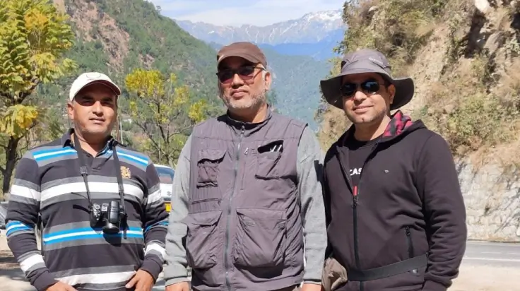
Team of Geologists from Energy Cluster, UPES Dehradun. From left to right, Dr. Uday Bhan, Dr. Girish Ch Kothyari and Dr. Atul Kumar Patidar.
A team of geologists from the Energy Cluster, School of Advanced Engineering, at UPES Dehradun embarked on a comprehensive study to unravel the mystery behind the recent events in Joshimath and provide crucial insights for future mitigation and infrastructure development.
Nestled within the captivating expanse of the Higher Central Himalayas, the historic township of Joshimath recently found itself at the epicenter of a geohazard crisis. Reports surfaced of ground subsidence, cracked homes, and oozing water, sparking concern for the densely populated region. Responding to the urgency, a trio of geologists from the Energy Cluster at UPES Dehradun, namely Dr. Girish Ch Kothyari, Dr. Atul K Patidar, and Dr. Uday Bhan, embarked on a meticulous field study in March 2023.
Delineating the reasons for undertaking the study, Dr. Girish Chandra Kothyari, says, “Each discovery in the Himalayas is a step towards enhancing societal resilience and shaping a better tomorrow. The future infrastructural development in these regions requires an in-depth geological analysis to mitigate natural hazards.”
Echoing his sentiments, Dr. Atul Kumar Patidar, says, “We are working in a tectonically-sensitive region. With updated chronological records and an understanding of paleo-seismic history, we can offer insights that pave the way for resilient infrastructures and sustainable living in the Himalayan terrains.”
The mission was clear for this trio – unravel the mystery behind the recent geohazard events and provide essential insights for future mitigation and infrastructure development. What they discovered was a complex interplay of geological, geomorphological, structural, and geotechnical factors contributing to the vulnerability of Joshimath.
Using a combination of satellite-based techniques, including AHP, SPIM, and geodetic RADAR, alongside traditional field geological mapping and geotechnical investigations, the UPES research team compiled a rich dataset for analysis.
The results painted a concerning picture: only 3.97% of the area was deemed stable, while 8.54% showed moderate stability. However, a significant 67.95% of the region fell within the moderately to highly vulnerable zones, signalling potential risks for future geohazards. Time series results indicated ongoing deformation, further emphasising the critical need for monitoring and mitigation strategies.
The study attributed the vulnerability of Joshimath to a combination of factors. Steep slopes in the upper Alaknanda Basin, highly sheared lithologies, and the impact of urbanisation, particularly infrastructure development, were identified as key contributors. The blocking of natural water flow paths exacerbated weathering and erosion, compromising the cohesive strength of the soil.
Explains Dr. Uday Bhan, Exploring the diverse facets of the Himalayas in sedimentology, geochemistry, and biostratigraphy is not just a scientific pursuit, but a journey to create knowledge that fosters geohazard mitigation.” He trusts that this research will provide valuable analogs, contributing to safer environments and informed decision-making for the future development of the region.
In essence, the collaborative efforts of the UPES geologists have not only unveiled the complexities of Joshimath’s vulnerability but also provided a blueprint for geoscientific studies in similar terrains. Their findings are instrumental in crafting effective geohazard mitigation plans and ensuring sustainable infrastructural development in the face of evolving environmental challenges.
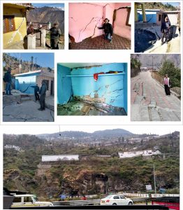
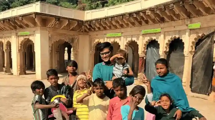
Damaged zones in the upper reaches of the Joshimath region. A team of geologists from the Energy Cluster at UPES Dehradun interacting with locals and collecting ground data to assess potential causes of geohazards in the Joshimath region. Wide cracks in the walls, damaged foundations of homes, and land creeping in the middle part of Joshimath (near the main bazaar) are visible in the pictures. A panoramic view of Joshimath village from the Hathiparwat side (Badrinath highway) is provided at the bottom, indicating an average slope of approximately 56 degrees in the Joshimath region.
Kama Choudhary
The writer is a part of the UPES editorial team
UPES Admission Enquiry
Trending Post
-
![]()
-
![]()
-
![]()
Student placed at Microsoft with 50 LPA shares how he aced his job interview
09/09/2022By Ekta Kashyap


Related Articles


Subscribe to UPES Blogs
Join our community for exclusive stories, insights, and updates
By clicking the "Subscribe" button, I agree and accept the privacy policy of UPES.